• Skip to main content
  • Skip to footer

Midland Ancestors

Interested in Family History? Discover your Ancestors from Birmingham, Staffordshire, Warwickshire & Worcestershire.

  • About Us
    • General Information
    • Contacts
    • Local Groups
      • Birmingham Group
      • Bromsgrove Group
      • DNA Special Interest Group on Facebook
      • Heraldry Group
      • Kenilworth Group
      • London Group
      • N. Staffs Group
      • Stourbridge Group
      • Wolverhampton Group
    • Publications
    • Society Constitution
  • News
    • Newsletters
  • Events
    • Calendar
    • Hybrid & Online Events – How They Work
    • Family History Classes
    • Coach Trips and Outings
  • Resources
    • Introduction
    • Midland Ancestors Family History Centre
    • Members Interests
    • Search Services
    • Birmingham
      • 1888 Maps of Birmingham
      • Tracing Your Ancestors in Birmingham
      • West Midlands BMD (New Tab)
    • Staffordshire
      • Staffordshire Municipal Burial Indexes (New Tab)
      • Staffordshire BMD (New Tab)
    • Warwickshire
      • Tracing Your Ancestors in Warwickshire
      • West Midlands BMD (New Tab)
    • Worcestershire
      • Tracing Your Ancestors in Worcestershire (New Tab)
      • West Midlands BMD (New Tab)
    • Links to Record Offices, Societies etc.
      • National Resources
      • Archives for Staffordshire Warwickshire & Worcestershire
      • Local & Neighbouring Groups and Societies
  • Online Shop
  • Join & Support Us
    • Membership
    • Volunteering Opportunities
    • Support Us
  • Login
    • Members Area
    • Officer Area
You are here: Home / Resources / Search Services / Search Services for Staffordshire, Warwickshire and Worcestershire / 1888 Maps of Birmingham

1888 Maps of Birmingham

A few years ago Midland Ancestors acquired a large number of very detailed street maps of Birmingham and its surroundings that were published by The Ordnance Survey around 1888-1889. The maps are 41″ by 29″ covering an area of about 500 yards by 350 yards. The scale of 1:500 is such that pillar boxes, lamp posts and garden details can be seen.  When linked to addresses in censuses and in other records, you can begin to build a picture of the circumstances in which your ancestors lived.

We have about 200 maps covering mostly the Warwickshire parts of the city. We do not have many maps for the Worcestershire and Staffordshire parts of the city. The whole area can be described as bounded by Perry Barr to the North, Small Heath to the East, Moseley to the South and Bearwood to the West.
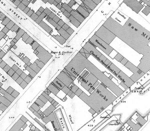
Often there are two copies of each map, one copy in very good condition and another  ”working copy” that has been marked up by hand, occasionally showing house numbers – an invaluable asset for family historians with census records, or access to contemporary street directories.

Digitisation is completed and all of the physical maps have been sold, but it is still possible to order digital maps from our online shop. Click Map Index to see a very comprehensive listing of street names, churches, schools, pubs etc. You can download that and save it to your local machine. Use this index to find which maps cover your area of interest.

Or you can contact John, our Map Advisor  by e-mail at maps@midanc.uk who will be only too pleased to help.

Be aware that long roads and streets could be covered by three, four or more maps. The maps, which take the form of Adobe Reader files (.PDF), will be delivered electronically.


Footer

Federation of Family History Societies

FFHS

Society of Genealogists

SOG

Recent Posts

  • Family History Centre Access
  • NEWSLETTER – NO. 31
  • Volunteering Opportunities
  • Members Area
  • Family History Centre News

Looking for something?

UK BMD
  • Sitemap
  • Terms & Conditions
  • Privacy
  • Cookie policy

Midland Ancestors is the public face of the Birmingham & Midland Society for Genealogy & Heraldry
The B M S G H is registered as a Charity in the United Kingdom: No. 505916 © 2023 · B M S G H · Site Developed by TechWizard